

The last time I did the Cave Creek / Skunk Tank Loop, I was very new to Arizona hiking, with nothing much under my belt other than suburban Phoenix-area trails with the hiking club from work.
Though I am now used to solo hiking, and in better shape, I expected today’s hike be fairly taxing, as I had not exercised at all, not even a walk to the post office, since my short jaunt through the sand storm at White Dunes.
Between breathing all the dust that day, and the cold the next day at Trinity Site, and serious allergies back in Phoenix, I have not felt all that great the past week. Breathing has been difficult, to the point that I’ve often only been able to speak a sentence at a time.
If April 7, had not been a once in a lifetime opportunity, I probably would have stayed at home. But precisely 100 years ago, today, “A.B.” carved his initials in a rock next to Cave Creek.
I’ve tried researching who might have been named “A.B.” in the Seven Springs / Cave Creek area at the beginning of the 20th Century. With nothing to go on but initials, the search was fruitless. Most likely, A.B. was a rancher or miner, as there was nothing else that far north of Phoenix 100 years ago. The “City” of Cave Creek was incorporated in 1870, but the census does not show independent figures for it prior to 1980. According to the Cave Creek Chamber of Commerce, it did not start growing until after World War I, which the U.S. entered the day before A.B. carved his initials in that rock.
The dirt portions of Cave Creek Rd. are in the best condition they have ever been. Usually, there is a bit of washboarding here or there, but it was really smooth. Easily car drivable, even at the two wet crossings.
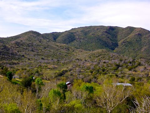
From the Cave Creek Trailhead, immediately north of the CCC Campground, Cave Creek Trail #4 heads south along the west bank of Cave Creek, past the campground, crossing FR 24B at .60 miles. On the left, Cartwright Ranch is an occupied, working, ranch. Just past the the ladder gate — “gate #1” on the GPS route — is the signed intersection with Cottonwood Trail #247, which this counterclockwise loop returns on. Stay right on Cave Creek Trail #4, as it follows the now north bank of the creek.
Whether Cave Creek Trail #4 is on the north bank, or the south bank, it is flat and mostly smooth. Even casual city hikers should be able to do it, no problem. (Though they will want to turn back after reaching the A.B. Rock, as the hike gets considerably steeper and rockier once it turns onto Skunk Tank Trail #246.)
Later in the year, Cave Creek Trail #4 has great fall color, which I’ve so far neglected to photograph. In the spring, it has an incredible variety of flowers. For the whole 10-mile loop, I photographed at least two dozen different species!
The abandoned Ashdale Ranger Station is 1.25 miles into the hike. I thought about checking it out, but a few campers had pitched tents there and I did not want to wierd anybody out.
I’ve hiked Cave Creek as late as mid-May and there has always been water in the creek. It’s only at the west end of the canyon, as the creek turns south, heading towards the Spur Cross trailhead, north of the city of Cave Creek, that the creek starts to run dry. Unless flow is unusually heavy, this hike’s four creek crossings can all be done dry with a bit of rock hopping.
The first creek crossing is at 1.9 miles, immediately after gate #2. I had a devil of a time opening the gate, as the chain link was really wedged in tight. I often wonder what all the fences and gates are for in rural Arizona when there are no cattle, or even signs of cattle — i.e. 💩 — in the vicinity.
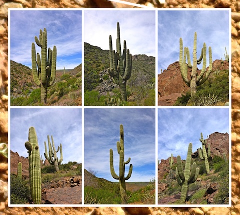
There are a ton of saguaro in the canyon, and on the climb up Cottonwood Trail #246 to Skunk Tank.
The A.B. Rock is about 4.0 miles into the hike, on the ground, to the left of the trail. It is obvious. It was pretty cool to be there exactly 100 years later, to the day. I wondered where his life led him. There’s some good rocks to sit on, so stop for a break and have a beer for A.B.
The third creek crossing is just after the A.B. Rock, and it is only a few hundred yards to the Skunk Tank Trail #246 intersection. New River Mesa is west, and Skunk Ridge immediately south. If you continue south on Cave Creek Trail #4, the Spur Cross trailhead is another seven miles.

Turn left, up Trail #246. The trail is steep, fairly rocky, and often indistinct. (A lack of foot traffic between Cave Creek and Skunk Tank, combined with heavy spring rains, has caused a lot of low growth.) The trail is 700 AEG in slightly over a mile, but seems steeper. Thankfully, there are plenty of switchbacks.
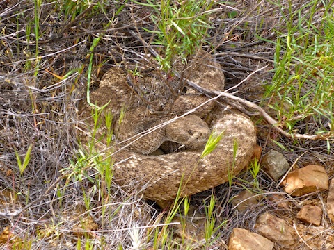
In Arizona, you can pretty much run into a rattlesnake anywhere, any time of year. (There is no truth to the rumor furry snow snakes prey on jackalope.) Even in the middle of a creek. I only occasionally get rattled elsewhere in Arizona. But I get rattled every damn time I hike in Cave Creek / Spur Cross between the months of March-October. It is inevitable.
As a result, I hike with my head down, scanning 5-10 yards ahead, paying special attention to the underside of any brush. (Snakes like warmth, not heat, and will seek cool shade when temperatures are at their peak.) Despite my precautions, snakes are, well, snakes. They don’t survive predators by being easily spotted outside their den.
So, it was just short of Skunk Tank that I almost stepped on a Western Diamondback curled up under a trailside bush. I think my eyes saw it, but my synapses didn’t fire until I had actually put my foot down — less than 12″ from his head! 😳 He rattled, and I jumped back. Luckily, no strike. Unfortunately, it was bit steep to the right, and he was to the left. And not moving. Thanks Cerberus. Eventually I worked my way left, well clear, and keeping an eye for any of his pals.
If you do get bit, or suffer some other catastrophic injury, beware that you will not have even 1-bar cell phone reception anywhere on this hike. You will need to use your SPOT or PLB to signal for help. You do have one, don’t you?
Just before encountering Cerberus, I sprained my left ankle. Thankfully, I could still walk. But I tweaked it once or twice every one of the final miles.
Skunk Tank had a good sitting rock, so I took a lunch break there.
Most of the day was overcast, with a welcome cooling breeze. But when the sun peeked out, particularly on the upper reaches of Cottonwood Trail #246, near the Quien Sabe Trail #250 intersection, it got quite warm.
By the time I reached that intersection, 6.5 miles into the hike, I was tired. I guess I’ve been lazier than I thought. I think I need to get back to doing North Mountain a couple of times a week. Despite the distance, the Trail #250 instersection is only two miles from the trailhead, but with still four miles to hike. On a sore ankle.
Just before Quien Sabe Spring, there is a log that was burned in the 2005 Cave Creek Complex Fire. It makes a good sitting log. I took another break. Now my neck was killing me. (The price I pay for looking down for snakes …)
Fortunately, after the Quien Sabe Trail #250 intersection, it is mostly downhill the four miles back to the trailhead. No whining, and I still got down low to take flower photos.
About 9.2 miles into the hike is the Cottonwood Trail #247 intersection. Just after that is gate #4, by Cartwright Ranch. It seems to alway be open, despite having a v-walk thru for humans. Just after that is the fourth creek crossing, before rejoining Cave Creek Trail #4, the stairs at gate #1, then back up to the trailhead.
Directions: From Pima Rd. & the 101, drive north on Pima Rd. for 12 miles. At the first stop sign, turn right onto Cave Creek Rd. Pass by Bartlett Dam Rd., after which the road becomes very twisty. Mind your speed. Also, note the green MCDOT mileage markers. Just past the Sears Kay Ruins, Cave Creek Rd. turns to car drivable dirt (with a few short paved sections, primarily wash crossings.) The Bronco Trailhead is at MCDOT 8. The trailhead is about MCDOT 12, a mile north of Cartwright Ranch. It is the next left after the CCC Campground.
GPS File: Cave_Creek_Skunk_Tank_Loop
Distance: 10.21 mi.*
AEG: 1,766 ft.*
Time: 4h 30m (minus breaks)
* If you hike to the A.B. Rock, & back, that is a 8.0 mile, 800 AEG hike, with fewer snakes and a lot more shade.
Cave Creek / Skunk Tank Loop Video
Hiking Cave Creek / Skunk Tank Loop from Preston McMurry on Vimeo.