

One of the things I decided to start doing this year is more hikes in the cooler months closer to home. Partly because it would save travel, partly because my wife could stay home and do her thing, but mostly because I thought it might be helpful to document the areas locals hike most often. (Or help winter visitors — of which Phoenix has many — find accessible trails to hike.)
The first hike on this winter’s Valley of the Sun Tour, was last week, hiking Miners Needle Loop out of the popular Peralta Trailhead at the far east end of the Valley. This week, I headed the opposite direction.
The last time I hiked in Estrella Mountain Regional Park was six years ago. Other than Gadsden Trail being miles of deep, sandy, wash, Estrella’s trails were very mellow. Large mileage is available without doing an out & back, which I always try to avoid.
In 2011, I hiked from the rodeo arena. I hiked all of Butterfield Trail, a bit of Gadsden Trail, almost all of Pederson Trail, some more of Gadsden, then all of Coldwater Trail. As my first “new” hike in Estrella Mountain Regional Park, I planned to do pretty much the same, except this time doing all of Pederson, with maybe a quartermile of Toothaker Trail to get me back onto Coldwater.
I hit the road early, 5:20 a.m., to avoid the heaviest parts of rush hour traffic. Even heading away from Phoenix, it is quite heavy, but at least not a standstill like I-10 heading into downtown. Since it was way too early for photos & video, I stopped for breakfast at the Waffle House on Dysart. I’ve loved Waffle House ever since I was stationed at Fort Gordon for Signal Officer Basic Course in early 1990. (Right before the Gulf War kicked off.)
I must have eaten quick, because it was still pretty dark when I arrived at Estrella Mountain Regional Park. I spent some time checking my twitter feed, before enjoying another awesome Arizona sunrise. 🌅😳
I hit the trail at 8:05 a.m.
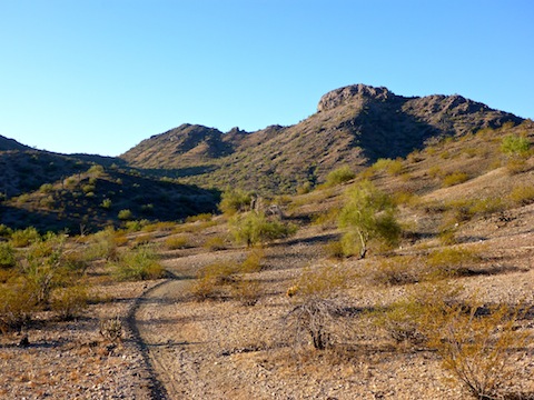
The Butterfield-Pedersen-Coldwater Loop is a long one, over 15 miles, that includes short bits of the Gadsden Trail and Toothaker Trail. Despite the distance, elevation gain is barely 1,000 ft. Most of the gain is due to numerous wash crossings. The only “climbs” of any sort — and they are barely noticeable — are 350 ft. over two miles to the Knobb Hill saddle on Butterfield Trail, 100 ft. from Cagett Wash to the white rocks on Pedersen Trail, and another 100 ft. to the Knobb Hill saddle on Coldwater Trail. Because the terrain is otherwise so flat, those two low saddles actually give some good views, of the Sierra Estrella if you are hiking south, and of the hangars at Goodyear Airport if you are hiking north.
Estrella Mountain Regional Park is a typical Valley of the Sun suburban trail system, with numerous formal, well-signed, trails. Getting lost, even at the far end of Pedersen Trail, is not an issue.
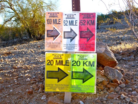
The Butterfield-Pedersen-Coldwater Loop starts from the rodeo arena gravel lot. Head past the tube steel vehicle gate, and up Coldwater Trail (the wide gravel road) for a quarter mile, then turn left on Butterfield. Throughout my hike, there were directional signs for a trail running ultramarathon. (The longer distances did five laps of this loop.) It made me think of “Signs”, by Five Man Electrical Band.
Butterfield Trail is 2.2 miles of smooth single track with a fair amount of steep little up & down wash crossings as it ascends towards the saddle on the east slope of Knobb Hill. Despite an erosion-induced rerouting around the steep 80 ft. hill that used to mark its high point, Butterfield Trail is rated “moderate” by Maricopa County Parks & Recreation. (But then County Parks also rate Ford Canyon as ⬥⬥ “hazardous” when it threatens no more than a sprained ankle.) 🙄
Turn west on Gadsden Trail for 0.7 miles. To the east, Gadsden is deep, sandy, wash, but this short connector follows a spur with wide, smooth, trail surface. I passed a trail runner — one of only two people I saw all day — on this segment. At Pedersen Trail, turn south. Stock cars running at Phoenix International Raceway, five miles distant, can easily be heard here.
Pedersen Trail, rated “moderate-difficult” by County Parks, is actually easy, but very long, more than half the Butterfield-Pedersen-Coldwater Loop’s mileage. Pedersen is best considered in three segments.
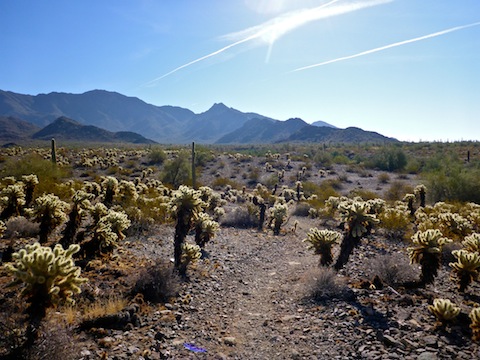
The first Pedersen Trail segment, south from Gadsden, is pebbley single track. There is another ton of wash crossings, but the trail routing means they are not as steep as on Butterfield. Pedesersen has been optimized for mountain bikes, of which there are many more tracks than human boot prints. Pedersen has a TON of cholla, mostly teddy bear cholla, though I also spotted some buckhorn cholla. Six years ago, the cholla actually blocked the trail at points; now it is clear, except for the odd fallen ball. At Corgett Wash, taking the Homestead Trail west will reduce your day’s mileage by 1.5 miles, to ~13.5. That’s the way the trail runners went. I continued another half mile to this loop’s high point, where I took my first break.
The second Pedersen Trail segment heads west on a jeep trail. It is rocky for the first half mile, then turns to deep sand for the next two miles. It takes less time & effort to hike to the side of the road, on the desert, which tends to have a firmer surface. Pedersen slopes gently down; the housing developments on Estrella Parkway are visible in the distance.
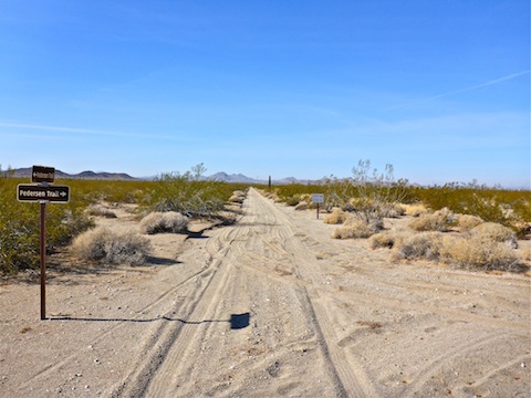
The third Pedersen Trail segment heads north on 155th Avenue. (Yes, that is what the jeep trail is called.) There’s still some sandy spots, but it is a firmer surface than the second segment. In a mile, is the west end of the Homestead Trail. I thought I saw a trailer parked there, but it turned out to be large tent full of tables, chairs, cots, Coleman stoves, and two liter bottles of soda for the trail runners. Unfortunately, no beer. I took advantage of the shade, for my second break.
Just north of Corgett Wash, is the west end of Gadsden Trail. I-10 is visible 12 miles northwest. If you head east on Gadsden, you will shave another half mile off your day. Whoa, Nelly.
From Corgett Wash, Pedersen Trail turns northeast, following an unnamed wash up to the outcropping of white rocks. Just after the white rocks, head south on Toothaker Trail for .25 miles, then east on Gadsden Trail for another .25 miles to Coldwater Trail.
Coldwater Trail is 3.3 miles long. From Gadsden, Coldwater is a fairly rocky mile up to the west slope of Knobb Hill, which rises 600 ft. above the trail. A quarter mile past the saddle, Coldwater widens and smooths out. The trail runners had another support tent at the corral. While the day started out cool & breezy, it had become warm & sunny, so I took a short break in the shade. I only had a mile to go, but I earned it. From the corral, back to the rodeo arena, Coldwater becomes the wide gravel road the loop began on 14 miles earlier.
Directions: Head west on I-10 to Exit 126. Then go south on Estrella Parkway for 5.0 miles. Just over the Gila River, turn left onto Vineyard Ave. In a half mile, turn right into the park, onto Casey Abbot Dr. After paying the entrance fee — it helps keep our parks nice! 🙂 — stay on the same road for 2.0 more miles, as it turns south, eventually ending at the rodeo arena.
Park Map: Estrella_Mountain_Regional_Park_Trail_Map
GPS File: Butterfield_Pedersen_Coldwater_Loop
Distance: 15.79 mi.
AEG: 1,022 ft.
Time: 5h 28m
Hike Video
Hiking Butterfield / Pedersen / Coldwater Loop from Preston McMurry on Vimeo.
Thanks, P. Looking at the photos and video, it is hard to believe you are close to the city. Liked the music, too.
Only because I didn’t include the audio of the stock cars at PIR. 😁