

I was thinking of heading back out to the Dripping Spring Mountains, on the undefined border of Gila County & Pinal County, for some more mine exploring, but decided instead to finish up my exploration of the Buckeye Copper Mine.
When I last explored Buckeye Copper Mine, in 2017, I ran out of storage on my camera’s memory chip. Then the camera’s battery ran out of power. I ended up using my blurry cell phone to shoot my final video segments. So, I had to skip some of the prospects & shafts south of the main workings, near the mine’s well. 🚫🔋
Today, I finally returned to finish up my mine exploration.
The road to the Buckeye Copper Mine’s main workings & ghost town is west of the road I took today, which passes by Southwest Gas’s abandoned (?) Gila Compressor Station, and Poison Well, on the way to my trailhead at Buckeye Copper Mine Well.
Whereas a car might get up the road to the main workings & ghost town, a car should not attempt the road to Buckeye Copper Mine Well. I took it slow in my stock Acura RDX SUV, and other than spinning at one wash crossing, had no problems.
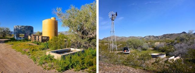
First stop, 2.0 miles south of Agua Caliente Rd., was Poison Well. One wellhead was capped; the other wellhead had a tap that gave clear water. (Being worried about the name — “Poison” — I did not try it.) Just across the wash was the main well area, with another wellhead, a cement spring box, a large yellow plastic tank with a tap, and a corrugated metal tank. The spring box had water, the tap gave water, and the tank had crystal clear water. I could have swum in the metal tank (for a few feet). 🏊🏻♂️
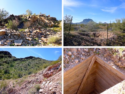
My second stop, 2.0 miles south of Poison Well, was to check out a prospect — X literally marks the spot — I had seen on the topo. A half mile up a small canyon, it is listed at Prospect #1 on my the attached GPS route (see below). No artifacts, or miners garbage: Just broken rock.
My third stop, 5.0 miles south of Agua Caliente Rd., was to check out Prospect #2. On the south slope of a small hill, 0.3 miles north of the jeep trail, it had a lot of broken white rock. Really beautiful stuff.
My final stop was at Buckeye Copper Mine Well, 5.8 miles south of Agua Caliente Rd. The spring box, metal tank, and two medium size blue plastic tanks, were all dry. But at least the windmill works! 😏
About 80 yds. west of Buckeye Copper Mine Well, on the edge of a wash, is Shaft #1. It is a vertical shaft, with the top ten feet, or so, shored with boards. It is fenced, but not gated. I could not see the bottom and saw no evidence of a lift.
Note: All the jeep trails in this mine exploration are are unnamed and unnumbered.
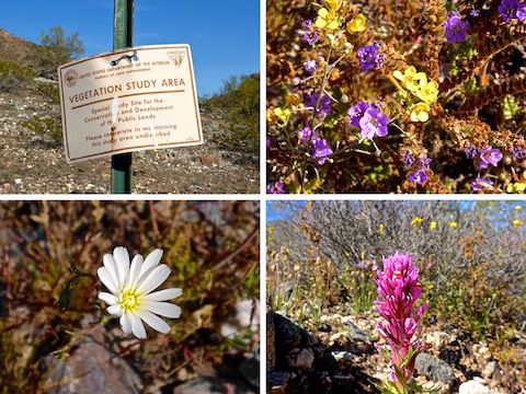
I walked north on a jeep trail, towards the saddle at Hill 1475, which had an unmarked prospect on its slope. Not much there. Across the jeep trail from Unmarked Prospect #1 was a BLM “vegetation study area”. All I saw were creosote.
From the saddle, there was good views northeast towards the White Tank Mountains and Arlington Mesa. Less salubriously, I could see the white roofs of Hickman’s Egg Ranch, home to four million hens. Orders of magnitude smaller egg farms smell hideous: No wonder folks in Tonopah are suing them! The Palo Verde Nuclear Generating station was out of site, behind Hill 1299. ☢️
Prospect #3 was fairly large, chiseled out of a canyon wall like Prospect #1. Only thing I found was some pretty purple and yellow flowers.
Prospect #4 was a small pit, maybe three feet deep. 2.4 miles into my mine exploration, I left the jeep trail, heading across a wash towards the north end of Hill 1299, where Shaft #2 and #3 are located, the ones I missed out on in 2017.
There were two holes at Shaft #2: One a foot or so deep, the other maybe five feet deep. I figure the deep one was “Shaft” #2. The “shaft” wasn’t collapsed: It was a glorified prospect. Is that what passes for geologist humor? 🙄
“Shaft” #3, a hundred yards north, was similarly stunted. Those two “shafts” were my main hope for finding something cool, on the day. (Shafts are indicated on a topo by a square where the upper left half is a black triangle, while the lower right half is an empty/white triangle: ![]() ; there is no indication of depth.)
; there is no indication of depth.)
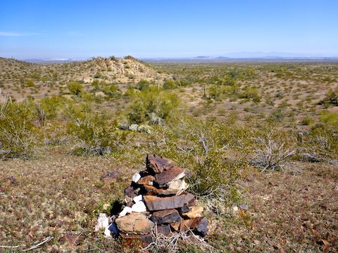
In between the two “shafts” was a good-sized cairn, apropos of nothing. Not a geocache, or even a benchmark.
It was like getting coal at Christmas.
I could see the Buckeye Copper Mine main workings & ghost town from “Shaft” #3, so I headed over towards the foundation of Building #8 to pick up another jeep trail.
The jeep trail went west for a ¼ mile, then south for a ½ mile. Prospect #5 was another pair of what appeared to be Army foxholes, minus the cold mud.
I backtracked a few hundred yards, then followed yet another jeep trail up a small canyon. It was steep, and broken, and the only real climb of the day. Prospect #6, near the top of the canyon was the largest I found all day, but again nothing stood out, other than a few broken sheets of corrugated metal and a very healthy palo verde. I was so grateful for the shade, I spent an hour snacking, rehydrating and checking twitter. (Shockingly, I had 2-3 bar LTE reception via Verizon!) 📲
On the other side of the saddle, near Prospect #7, I found a few rather dark orange rocks — maybe Cinnabar? — one of which I used as the thumbnail for my Buckeye Copper Mine exploration video (below). Otherwise, Prospect #7 was also a strikeout.
Neither Prospect #8 (another pair of foxholes), nor nearby Unmarked Prospect #2, had any artifacts or miners garbage. I was hitting so poorly, the lofty heights of the Mendoza Line were out of view. ⚾️
Prospect #9, cut out of a small hillside had nothing to offer other than a great view of Woolsey Peak. Cutting cross country to Buckeye Copper Mine Well would have been easy, but I decided to take jeep trails back to the trailhead.
So, my recommendation is that only mineral collectors should check out this hike, while people with a more casual interest in mining, should stick to Buckeye Copper Mine’s main workings & ghost town.
Directions: From Phoenix, head west on I-10 to Exit 109. Head south on Palo Verde Rd. for 6.3 miles to the school. Turn west (then south) on Old Highway 80 for 10.9 miles. Turn west on Agua Caliente Rd., which is paved, for .7 miles. At the split in the road, split right, staying on Agua Caliente Rd. as it turns to easily car drivable dirt. Once on the dirt part of Agua Caliente Rd., take the very first left turn, between some trees, onto an unnamed, unnumbered dirt road. Follow it for 5.8 miles to Buckeye Copper Mine Well. OHVs will have no problem; SUVs should go slow. Cars avoid!
GPS File: Buckeye_Copper_Mine_2 … Main Workings: Buckeye_Copper_Mine_Hargan_Mine
Distance: 9.91 mi.
AEG: 1,269 ft.
Time: 4h 13m
Off Roading to Buckeye Copper Mine Well Video
Exploring Buckeye Copper Mine Video
Mine Exploring Buckeye Copper Mine, Gila Bend Mountains from Preston McMurry on Vimeo.