
: \"The King of the Surf Guitar\"")
It’s starting to get warm down here in Phoenix, so I sent a twitter DM to my hiking & mine exploring buddy, @Prescottstyle (Paul), asking if he wanted to do anything up in higher elevation Yavapai County. Paul suggested Dosoris Mine. It took me awhile to figure out where Dosoris Mine was — in Dosoris Canyon, which is flanked by Maverick Mountain and Mount Tritle in the Bradshaw Mountains, just south of Prescott — and when I did, I was like “Enh, I don’t think so.”
Dosoris Mine is an 800 ft. bushwhack down Dosoris Canyon from FR 9403C, which connects Maverick Mountain to Mount Tritle. Then, of course, an 800 ft. bushwhack back up after the mine exploration. In the sort of dense Arizona scrub that grows in old burn scars. I asked Paul if he had a better idea.
Paul’s second idea was Blue Dick Mine. (No laughing at the back! “Blue Dick” is a type of Arizona flower, not an old west miner who hasn’t been to a brothel in awhile.) 😁
There are two ways to approach Blue Dick Mine: From Ponderosa Park, the round trip is 12.0 miles and 1800 AEG, with a steady rise, via FR 97B and FR 667. (Much the same route Paul and I followed to Big Chief Mine.) From Kendall Camp Rd., it is 7.5 miles and 1800 AEG via FR 79A and FR 9403C, with steep climbs, both in & out, to the Maverick Mountain saddle. We chose the latter.
In researching our expedition, I found a Blue Dick Mine exploration blog from 11 years ago. (I think the site is dead, but the pages are still accessible.) In 2008, they reported “at least three entrances”, “six levels and lots of shafts”, “beams … in exceptionally good condition”, plus ore cart rails and several foundations. The upper adit was collapsed, but a guy my size was able to squeeze in; the lower adit was an easily penetrable 3’x3′ opening — but I did note the cross beam was cracked. 🤔
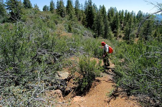
From FR 79, the first mile was an easy stroll past the old apple orchard. The next mile of foot trail was a 750 ft. climb to the Maverick Mountain saddle. When dry, it is slippery with pea gravel. Today, mountain runoff had a small creek flowing down the middle of the trail, adding mud to the slipperiness mix. The climb is a good blow, and having done no elevation the past several months — certainly not at 7,000 ft. altitude! — I took several quick breathers.
We followed FR 9403C as it bent south for a level & sun exposed 0.6 miles, before it began descending through shady pines, towards the knob labelled Hill 6507 on the topo. From the pines to FR 667, FR 9403C is an exceptionally steep & rocky descent. (A dirt biker we met at the bottom actually turned around rather than go up it.) Paul nicknamed the descent “The Eiger“, after the famous Swiss mountain.
From the bottom of “The Eiger”, Paul & I hiked a mine access road for a few hundred yards, before following some animal trails down slope, so we could approach Blue Dick Mine from below.
The first thing we spotted was a bit of ore cart rail laying in the wash then, up above, another bit poking out of the edge of the tailings pile. We climbed up the short, but loose slope, to find ourselves on a small plateau. A pair of well-preserved ore cart tracks, with many ties still intact, bent its way across the plateau towards a small draw. 🛤
We were at Blue Dick Mine.
Blue Dick Mine, located in Hassayampa District, was supposedly active from 1902 to 1928, when V. F. Grove And Sons ceased operations. But the February 24, 1890, edition of the New York Times, in an article on the Walnut Grove Dam collapse two days prior, reported that John McDonald, owner of the Blue Dick Mine, had observed the disaster from the “Dozoris [sic] Divide”. Also, the Arizona Geological Survey, in its Blue Dick Mine Data Summary, mentions that in 1983 the owner was Al Goettel, who was wanting to lease the claim to someone from Mohave County.
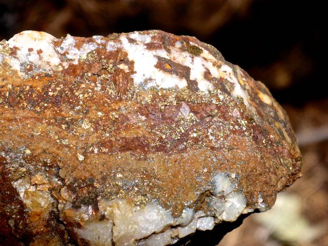
When it was operating, Blue Dick Mine produced the usual Arizona mineral suspects: gold (Au), silver (Ag), copper (Cu), lead (Pb) and zinc (Zn). Plus, it was also known that arsenopyrite, chalcopyrite, galena, pyrite, sphalerite and tetrahedrite were present. From 1902-1928, it produced $200,000 in revenue. Not sure if that is gold only, or including other minerals.
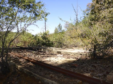
There was a foundation at the mouth of the small draw. It was obviously Blue Dick Mine’s processing area. Paul and I could not determine how much, and what manner, of processing occured, as the only equipment present were a couple of rusty, shot up, 50 gallon drums, and some moderate-sized bolts sticking out of the foundation. 🔩
On the opposite side of the draw from the foundation was a dig that looked like it could either be a prospect or a small surface trench.
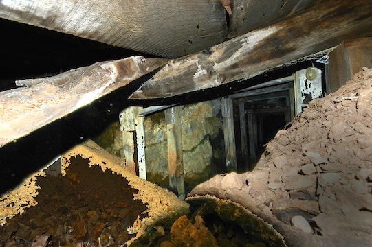
Paul and I followed the or cart cart tracks 50 yds. around a curve to Blue Dick Mine’s lower adit … which was collapsed. The cross beam which had been cracked in 2008 had given way, and more earth had slid from the side, all but blocking the adit. What opening remained was even smaller than the one I low-crawled at Webber Mine three years, and several pounds, ago.
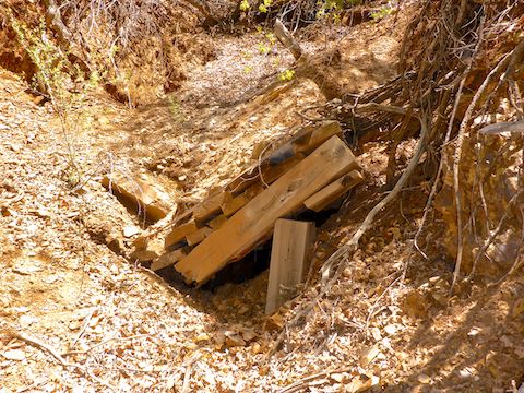
Given the cracked cross beam, I was not surprised, but I was still bummed. I poked my camera in anyway for some pictures & video.
Fifty yards east, and 40 ft. up slope, was Blue Dick Mine’s upper adit. While a guy was able to squeeze in 11 years ago, more collapse in the intervening years made it impossible for this fat man to get in now. Fiddlestix. ⛔️
From Blue Dick Mine’s upper adit, we followed the mine access road northwest to FR 667. Just before the forest road, Paul spotted the miners dump. On the opposite side of the access road, I spotted a foundation heaped with white stone chips. There were no crucibles, but Paul thought the presence of a “fire brick” indicated it was the assay. That would make sense, since it guarded access to the mine.
There was another, slighty larger, foundation on the side of the assay opposite the access road. Probably the Blue Dick Mine office / living quarters. Other than the the rusty old tin cans in the miners dump, there were no artifacts in the area.
Paul & I thought we were done with our exploring, but as we headed east along FR 667, we spotted what is marked on the topo as a prospect. In fact, it is two side-by-side, irregular-shaped, shafts. They were so close, that stepping between them to get a decent photo was a sketchy proposition. The shafts did not look like one large shaft with collapse filling in between them. They looked like they may have connected to a tunnel from Blue Dick Mine’s upper adit.
Back at FR 9403C, we faced “The Eiger”. I’m not ashamed to say I took my time, taking a couple of minutes’ breather every 100 slippery, rocky, feet we climbed. I did not do much talking. The ¼ mile of shade north of Hill 6857 was most welcome, even though it continued to climb (albeit at more modest slope). 🥵
Once we reached the Maverick Mountain saddle, it was time to break out the hiking beer & enjoy an extended break. 🍻
It was nearly 4:00 p.m. by the time Paul & I got back to my always patient wife at the trailhead on FR 79, so after we dropped Paul off at La Casa Prescottstyle, we quick-timed down AZ-89 towards Phoenix, stopping to pick up a pizza at the highly recommended T-Bird Cafe in Peeples Valley along the way.
Directions: From Gurley St. in Prescott, head south on Mt. Vernon Ave., which becomes the Senator Highway. In 7.4 miles, just after the pavement ends, turn right onto the second dirt road, FR 79 / Kendall Camp Rd. Make a quick right & left to cross the Hassayampa River. Depending on surface conditions & water level, a car could handle FR 79. In 1.8 miles, FR 79A splits right. I’ve parked my SUV a ½ mile down FR 79A before, but this time was no bueno. Instead, I parked at the FR 79 / FR 79A intersection.
GPS File: Blue_Dick_Mine
Distance: 8.57 mi.
AEG: 1,874 ft.
Time: 4h 25m
Exploring Blue Dick Mine Video
Exploring Blue Dick Mine, Prescott National Forest from Preston McMurry on Vimeo.