

It’s been hard coming up with hikes the past six weeks.
The temperatures have usually been over 110° in the low desert around Phoenix. As a general rule of thumb, temperature lowers about 1° for every 300 ft. or so of elevation gain. Since my part of Phoenix — Sunnyslope — is about 1,400 ft., that means to get a hike under 90°, I would need to hike at an elevation of 7,400 ft. That means driving north of the Mogollon Rim, to some place like Flagstaff or Pinetop, or south to Mt. Lemmon or Mt. Graham, which are even longer drives.
Unfortunately, because it is now monsoon season, the Mogollon Rim, and the higher elevations, are receiving heavy daily rain. I don’t mind a drizzle, if I get stuck in it, but if I can plan around it, I will.
I thought about hiking Prescott, which is 5,400+ ft. But I wanted to get up another 1,000 ft. if possible, to lower the temperature a bit more.
It has been 30 years since I passed through Jerome, an old copper mining town turned artist community, on the north slope of the Black Hills, overlooking the Verde Valley. But the advantage is that the Black Hills — especially Mingus Mountain and Woodchute Mountain — met my elevation criteria.
There’s lots of trails on the summit of Mingus Mountain, which is relatively flat, more like a mesa. “Summiting” Mingus wouldn’t be any sort of challenge at all.
Instead, I put together a loop along the slopes of Mingus and Woodchute, mostly around Hull Canyon, but also taking in Mescal Gulch. The distance would be not too short and not too long, and with enough gain to feel like I worked, but not so much as to risk a coronary. (Certainly nothing like Harquahala Peak!) It looked like there would be some good views of Jerome, plus a pioneer cemetery, a mine and some whazzits? to check out.
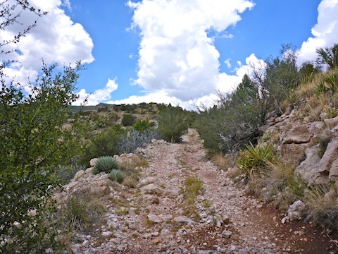
The hike starts out by crossing AZ-89A — there is no culvert, so keep an eye out for traffic — passing by Mescal Tank, then proceeding east on an apparently unnumbered forest road, through some nice shade. This, and all jeep trails, foot trails and cross country, throughout the loop, showed ample evidence of recent heavy rain. Some jeep trails appeared to have channelized runoff, with downslope sand patterns, and shifted small accumulations of dead grass. On flatter parts of the jeep trails, the ruts were either muddy or still held water. Off trail, the soil was quite loose, with even large rocks poor candidates for a solid foot hold.
A half mile into the hike, on the south side of the trail, there are the ruins of a stone-walled building. Just past the ruins is Mescal Spring. There is a dry spring box, and the spring is fenced off. I always wondered why some springs are fenced, and today the reason finally occured to me: So that animals would not pollute the water, at its source, with their droppings. I may be off base, but it makes sense.
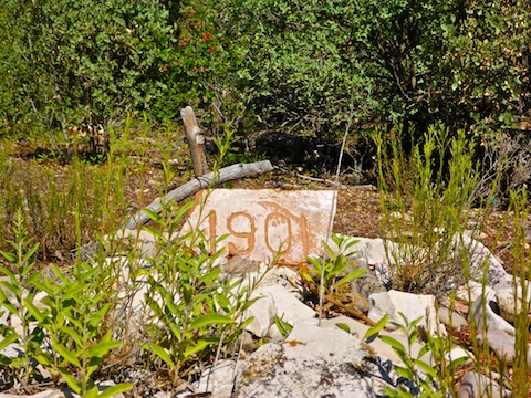
Just past Mescal Spring, I turned right, onto FR 338, which heads upslope towards North Mingus Trail #105, which takes you to the summit of Mingus Mountain. A half mile up FR 338, hidden back in the tree line, is a small graveyard. There are three anonymous graves there, although apparently one cross once had the name “C. Jones” on it. There is a collapsed mine shaft not far away, so perhaps it is a miner & his family?
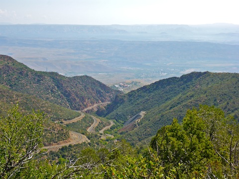
I headed back down FR 338 to Mescal Gulch. Just past the ruins, I turned north, heading across the wash, and up the left side of a ridge. If you follow my track (see link below), you will soon pick up a well defined old foot path. Honestly, it looks more like a decrepit Roman walkway, like it was once rough-paved with stone, with small parallel mounds defining much of its course. Halfway up, by a mound of stones, the path cross an obvious old road. There is a wood stake at the top of the ridge, but I could not locate a benchmark or geocache. A summit log would have been too silly. The Verde Central Shaft and Jerome High School — now occupied by art studios — were easily visible down Hull Canyon.
I could not find a path south off the ridge top, so I bushwhacked. Despite the lack of manzanita and cat claw, it was still slow going. It took me 15 minutes to go 250 yds. and descend 150 ft., until I bumped across a powerline right-of-way, where I was able to pick up a defined foot path. At the bottom of the ridge, in Hull Canyon, the trail splits. Going right would take you to the Jerome waterworks; I went left up a wash.
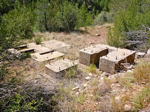
Finding rusty bits of metal in a wash is a good indicator of a nearby mine. I soon bumped across two sections of pipe, and several miscellaneous parts. Then I located what looked to me like a small boiler. Just up slope, through more thick brush, on a flat shelf, there were several cement structures with large bolts sticking out of them, that I took the bases for a boiler and small mill. Also on the shelf, through some trees, was what looked like a blown closed inclined shaft, with a drainage pipe sticking out. The odd thing was all the hard, gold-colored, foam laying about. It looked like the miners used it to keep things like vent pipes in place. Finally, just slid off the shelf, I found several thinner chunks of concrete that may have been foundation. 🤔
The whazzit? I meant to check out turned out to be the most massive cattle tank I had ever seen. Or at least that is what I thought until I found some faded paint indicating it was town property of Jerome. It had a neat welded plate marked with “T.O.J.” and a wave pattern. Next door was the purification plant, with “Danger: Chlorine Gas!” signs. The waterworks were audibly pumping through a 250 gal. minute / second (?) pipe laid in 1986.
I passed Walnut Springs on my way out to to AZ-89A. I was spent, so I walked over to a nearby pull out, sat down on a dirt mound, then texted my wife for pickup. I had 1-2 bar Verizon reception, but she must not have had any back at Mescal Tank, because after 15 minutes I had not heard. Not one to stand still long, despite my fatigue, I sucked it up, resolving to hike the reminder of my planned route.
FR 503A starts as a shallow climb. After a little over a quarter mile, I found a set of bolted cement structures identical to the ones I located earlier. They must be associated with the Jerome Grande Shaft.
From those structures, FR 503A gets rocky and pitches up. Despite the rocks, footing is never an issue, but the steepness is. I took several quick breathers before I got to the top of the climb, near the intersection of FR 500E, where I took an extended break. Unfortunately, I did not bring lunch, or even an energy bar. As much as I like salt & vinegar chips, they are a poor source of energy. 😕
After my break, I just ground out the miles along Woodchute Mountain’s slope, towards Hull Canyon, where I expected to find some decent shade. Thankfully, clouds were moving in. I could hear thunder in the distance, and was grateful for the sprinkles, which provided some relief without leaving me soaking.
Hull Canyon was indeed shady, as was most of the rest of the hike along FR 503A, including a forest of tall pines on the 3/4s of a mile descent to AZ-89A. Just before the highway was the one of the coolest cairns I’ve ever seen: A finely balanced single rock-wide tower. I’m surprised wind hadn’t blown it over! 😳
Crossing AZ-89A, then taking a short jaunt along Mescal Trail #547 back to Mescal Tank, before recrossing AZ-89A to the Prescott National Forest, is preferable to risking a rail-hopping walk along the highway itself. So, that is what I did. 😉
An out & back hike from the Mescal Tank trailhead, up FR 503A direct to Hull Canyon — the opposite of the direction I travelled — would be a great six mile, 900 AEG, walk in the woods.
After the usual post-hike trailhead rehydration — V-8 etc. — my wife & I repaired to Jerome, where I limped through town before we settled on linner at the Mile High Grill. The (two) Kolsch-style microbrews were crisp & refreshing, while the “Tot”chos were yummy!
Directions: From Phoenix, head north on I-17 to exit 287. Take AZ-260 northwest 12 miles to Main St. (AZ-89A) in Cottonwood. Turn left, but stay left, to make another left turn at the next major intersection, onto Cottonwood St. (also AZ-89A). Follow AZ-89A four miles to Clarkdale. At the fifth traffic circle, turn left, following AZ-89A south, through Jerome, for 10 miles. The trailhead is the large pullout on the west side of the road, at the large Prescott National Forest sign.
GPS File: Black_Hills_Loop
Distance: 8.91 mi.
AEG: 1,692 ft.
Time: 4h 30m
Hiking Videos
Hiking Black Hills Loop (Pt. 2) from Preston McMurry on Vimeo.