
")
It’s been almost four years since I last explored Big Bug Mesa. In 2014, I hiked up Pine Creek Trail #289 from Pine Flat. Last year, the Goodwin Fire ignited just west of Pine Flat, before growing to over 28,000 acres, threatening Spring Valley, Mayer and Poland Junction. It also burned the top of Big Bug Mesa. 🔥
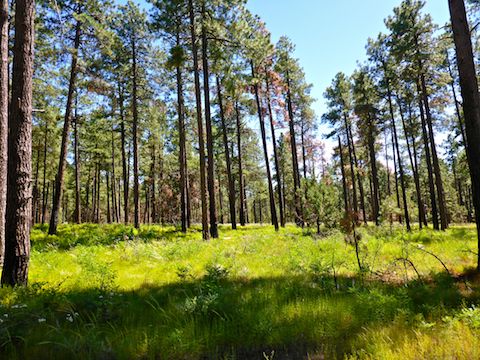
But I’ve seen recent reports that most of the trees are still healthy on Big Bug Mesa, so I decided to check it out.
I mapped out a loop around the mesa top that would be at least 13 miles, and take in several “whazzits”. (What I call objects I see on satellite view that I can’t identify, or otherwise wish to explore.) Part of my loop would be on jeep trails, part on mild cross-country terrain.
I needed the miles, as I have not hiked a foot since the Prescott Circle Trail last week.
To avoid the boredom of repetition, I staged out of Five Corners, rather than whatever remains of Pine Flat. FR 261 / Poland Rd. is car drivable dirt, though it does get a bit bumpy the final mile. Just watch out for 🐄.

There was already a pickup, with OHV trailer, at the corral when I arrived. The Big Bug Mesa area is popular with off highway vehicles: I saw some on top of the mesa last time I was here, and prescottstyle and I were passed by another on our Moscow Peak hike. I didn’t see any OHVs today and the pickup was gone when I returned at 2:00 p.m.
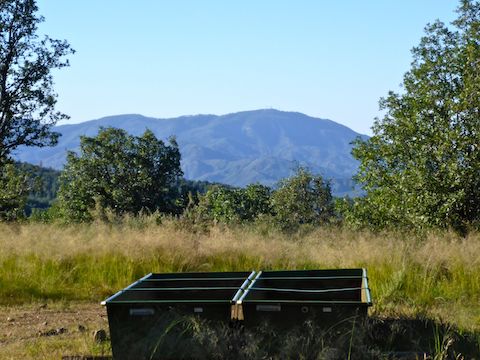
The first whazzit on my itinerary was just a bit up FR 103, the main jeep trail across Big Bug Mesa. It turned out to be a spring box with about 4″ of decent rain water in it. The water had to be rain, because there was no pipe feeding in from a spring.
After the spring box, I turned off FR 103, up an unnumbered jeep trail. Some recent fence work had been done along it, with silvery, unrusted barbwire, and trimmed log posts where the missing branches were still tan. It had a real good view of Mount Davis & Mount Union. ⛰
Not far after I joined back up with FR 103 I spotted some piles of rocks near some fencing. I thought it might be a graveyard, but I don’t think it was anything much. The rocks did not appear random, however.
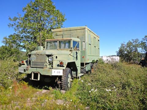
My next planned whazzits were a cluster of a half dozen near an old mining camp.
What I found were an orange 40 ft. Hyundai sea container. Next to the sea container was what I thought was maybe a 10k generator, but was actually a water purification unit; I did not see any gallon capacity on it. At the end of the sea container there was a surplus Army M809 5-ton 6×6 in dump truck configuration (M817). On the other side of the sea container, was the drum roller, with conical spikes, for road construction.
In all, there were three M809 5-ton trucks in the mining camp, all in woodland pattern camouflage, with bridge weight markers on the front grill and unit designations on the bumpers. It’s been 17 years since I retired from the Army, so on my hike video I bolo’d narrating the unit: One of the M809s was vehicle 59, from Foxtrot Company, 181st Brigade Support Battalion, 81st Armored Brigade, of the Washington State National Guard. 🇺🇸
The final whazzits were a 5th wheel trailer and a 500 gallon plastic water tank. Nobody was around, maybe not for years, as what I thought was a old stone fireplace turned out to be bags of cement that years of storms had turned to hardened cement.
After 30 minutes exploring the mining camp, I moved on.
The next interesting thing I found was a short wooden tower, that on satellite view looks like a pile of deadfall, which is common not only on Big Bug Mesa, but in all Arizona forests. The tower was too big to be a deer stand: It looked like a water tower, minus a reservoir.
A quarter mile away, I chanced upon a garbage-filled camp fire — a very common occurence on Big Bug Mesa — next to which was a cement box the campers had used for a bench. It had a cement slab top, and bent bolts along the side. It looked almost like a spring box except, like earlier, there were no pipes feeding it. Not sure what it was. 🤔
Where FR 103 turns south, I headed northeast on FR 103A. I thought I’d seen a whazzit on sat view, but turns out it was just deadfall. I went 1.5 miles on FR 103A, stopping at a clearing that had great views northeast towards AZ-69 and Dewey-Humboldt. FR 103A looks like it continues southeast to Grapevine Springs, but don’t hold me to that.
I backtracked up FR 103A a bit, before turning down an informal jeep trail. When it petered out, I continued cross country until I hooked back up to FR 103A. By the time I arrived at the next whazzit, eight miles into my day, my left shoulder was getting sore from my pack. Dunno why, as I was carrying my normal load.
On satellite view the whazzit looks like a collapsed 5th wheel, but it is a cattle tank lined with rubberized canvas. There was maybe a gallon or two of muddy water in it. 🤢
After checking out the tank, I ate lunch: G2, Cape Cod Sea Salt & Vinegar Chips, some home-assembled gorp, and a blue cheese buffalo wing chicken finger from QT.
There were a few other whazzits I wanted to check out, but with my sore shoulder I figured it best to bail to the trailhead, which was still over four miles away.
I shall return!
Directions: From Phoenix, head north on I-17 to exit 262. Take AZ-69 12.5 miles northwest thrugh Spring Valley and Mayer. Turn left onto FR 261 / Poland Rd. The car drivable dirt road follows Big Bug Creek for 10 miles to Five Corners. Watch out for 🐄! Park at the old corral.
GPS File: Big_Bug_Mesa_Explore
Distance: 12.83 miles
AEG: 890 ft.
Time: 4h 49m
Good one. I like the narration.
I figured I’d mix it up and bit from the usual slide show.