

Continuing my run of Superior-Miami-Globe area hikes, and wanting to start checking out some ghost towns, I hit on the idea of Bellevue. I could tell FR 349 was blocked by MF Ranch, as not only does FS Topo show a gate symbol at the claim boundary, but two gates are actually visible on satellite view. There is also another claim a few hundred yards west of MF Ranch, which looked like it might be occupied in its southeast corner. Therefore, my plan was to park at the intersection of FR 349, hike back north on it a way, go up a jeep trail, follow a contour line, drop into Mead Canyon, then head up a branch of Pinto Creek to the ghost town. After exploring there, I would check out some adits, shafts, and hills west of Gibson Mine.
I was able to follow the contour without much trouble, but did run into a few grab & stabs, including getting jabbed pretty good by some agave. ![]() Lots of dead manzanita on that ridge. The branch creek was easy travel. I did not see any no tresspassing signs. I got to the mill, which was the biggest I have so far seen. Was disappointed not to find any other historical structures. (On satellite view, the mill appeared to be some building ruins.) The entire Gibson Mine area has been extensively plowed, which probably explains the lack of old buildings. The only other building is a barn, of more recent vintage, with a huge pile of junk out front. After checking out the barn, I exitted west to climb the hill to look for adits and shafts. That’s when I discovered the no trespassing signs. Oops.
Lots of dead manzanita on that ridge. The branch creek was easy travel. I did not see any no tresspassing signs. I got to the mill, which was the biggest I have so far seen. Was disappointed not to find any other historical structures. (On satellite view, the mill appeared to be some building ruins.) The entire Gibson Mine area has been extensively plowed, which probably explains the lack of old buildings. The only other building is a barn, of more recent vintage, with a huge pile of junk out front. After checking out the barn, I exitted west to climb the hill to look for adits and shafts. That’s when I discovered the no trespassing signs. Oops. ![]()
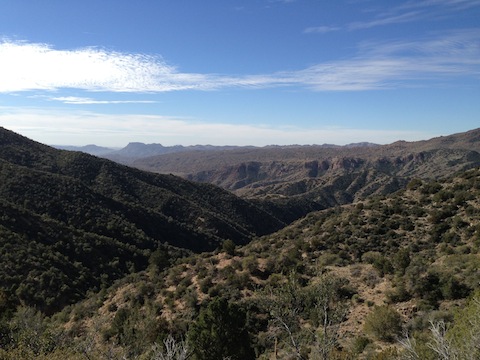
I had too many routes on my GPS, and so was a bit confused about which way to go. I ended up following a jeep trail west, down the south side of a canyon, but it was blocked by another signed gate. So, I took the unsigned, very rough old road west on the north side of the canyon. The view west was gorgeous. I followed a spur down to the canyon bottom. I got on a decent jeep trail east until I came to very steep (40% slope) rock fall / flume, which I had intended to go up to look for a whazzit?. So, I did. Did not see the whazzit?, so I headed off to look for the grave Cal Topo claimed was just east of the leach pit. Where the grave was supposed to be, I found junk. 50 feet away I found an approximately human-sized 6″ inch high pile of rock that was a different color than the surrounding ground. Maybe that was the grave?
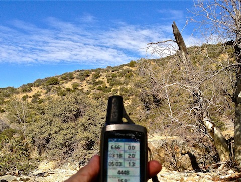
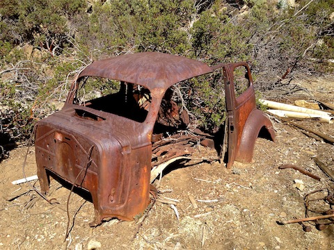
I then headed back up the branch creek to Pinto Creek. I took a break at the intersection, including airing out my feet. Afterwards, I decided to head east towards the claim I had avoided. I found a well-worn foot trail in the dirt, indicating that the claim likely was occupied. After checking out an old auto wreck, probably a ’36 Chevy, I turned back. At the top of the ridge, while following the contour, I lost my GPS. ![]() I spent almost an hour searching for it, including retracing my path along the ridge four times. (Easy to do, because I followed my own tracks.) I know I lost it up there, because I had checked it only two or three minutes before realizing it was gone.
I spent almost an hour searching for it, including retracing my path along the ridge four times. (Easy to do, because I followed my own tracks.) I know I lost it up there, because I had checked it only two or three minutes before realizing it was gone. ![]() As a result, my stats are an estimate based on what I remember from the last time I looked at the GPS.
As a result, my stats are an estimate based on what I remember from the last time I looked at the GPS.
Lots of planes overhead, including some fighters that left curly contrails. ![]()
GPS File: Bellevue_Ghost_Town_Gibson_Mine
Distance: ~9.00 mi.
AEG: ~1,800 ft.
Time: ~4h 30m
Bellevue Ghost Town & Gibson Mine from Preston McMurry on Vimeo.