

The Battle of Big Dry Wash took place on July 17, 1882, on the edge of a small canyon above East Clear Creek, Arizona. There, five troops, plus indian scouts, of the 3rd and 6th Cavalry Regiments fought a band of about 60 White Mountain Apache led by Na-tio-tish.
Na-tio-tish thought he would be ambushing future Army Chief of Staff Adna R. Chaffee’s 45 troopers,, but failed to set sentries. Famous western scout Al Sieber saw through Na-tio-tish’s plan, and instead the Apache were themselves surrounded by nearly 200 soldiers.
The Battle of Big Dry Wash lasted four hours until a heavy rainstrom, with hail and lightning, halted proceedings. The surviving warriors used the cover of darkness to eascape back to the White Mountain Apache reservation.
The Apache lost 16-27 warriors, including Na-tio-tish, to only two killed and six wounded for the cavalry. Four troopers were awarded the Medal of Honor: 1st Sgt Charles Taylor, 2LT Thomas Cruse, 1LT Frank West and 2LT George Morgan.
I’ve had the Big Dry Wash battlefield in my to-do list for a half dozen years.
The problem for me has been that the battlefield is eight miles — as the buzzard flies — north of the Mogollon Rim. Hiking out & back from General Springs Cabin, just north of FR 300 / Rim Rd. would make for a long & exhausting 20 mile & 1700 AEG hike. Maybe back when I was a young paratrooper at Ft. Bragg. Not now that I am a 56-year old fat man.
In the mean time, I thought about doing a through hike of Arizona Trail Segment #27, the Blue Ridge segment. AZT #27 is ‘only’ 15.4 miles and 1500 AEG. One way. So, just within my limits.
Unfortunately, there is no actual trailhead where AZT #27 ends on Highway 87. At least not one with a pit toilet, so that my always accommodating wife would not be stranded while performing shuttle duties.
So, the plan I came up with was to hike AZT #27 from the Battle of Big Dry Wash historical marker on Rim Rd. / FR 300 to Rock Crossing Campground, just north of East Clear Creek and the Blue Ridge Reservoir. And, if energy permitted, bushwhack across the wash in question to the battlefield.
If you want a more discrete, or simply less crowded, parking spot, there is a small clearing across FR 705 from General Springs Cabin. Then you can Superman it out & back to the battlefield. Alternately, an out & back from Rock Crossing Campground to the battlefield would be only 7.0 miles and 1300 AEG. I started from FR 300 / Rim Rd.
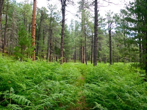
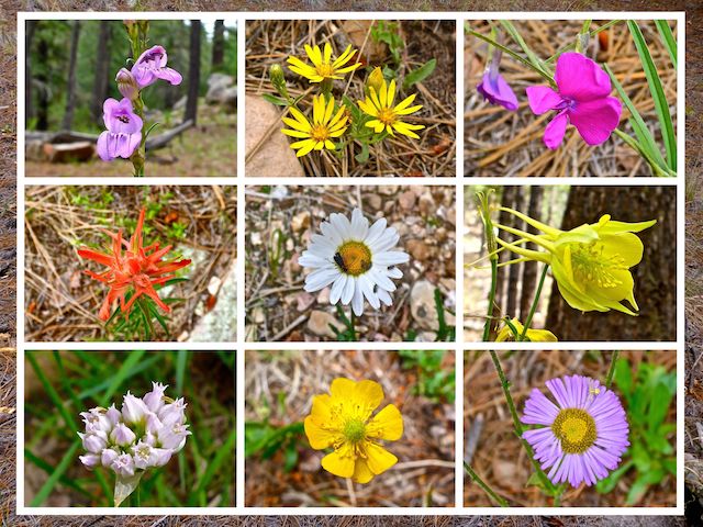
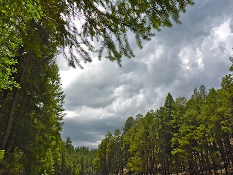
The first 3.3 miles of Arizona Trail Segment #27 cover the exact same 3.3 miles as the General Springs & Fred Haught Canyon loop I hiked two months ago. The recent heavy rainfall — Flagstaff set a one week record of 11.22″ — meant General Springs Canyon was very green. The ferns took full advantage of the bonus moisture, but there was little, if any, increase in flowers. Despite all the rain, the creek had no flow and even smaller pools than before. The trail surface was firm & dry.
I hiked as fast as I could, because I knew further heavy rain was very likely. The most tiring part, though, was getting up & down a couple dozen times for flower shots. I took my first break just after AZT #27 splits left from the Cabin Loop. 🌸
The climb from General Springs Canyon up to FR 9709J is a switchbacked 250 ft. in 0.4 miles. It was immediately obvious there were fewer flowers. (That would remain so all the way to Rock Crossing Campground.)
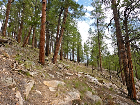
From FR 9709J, Arizona Trail Segment #27 crisscrosses, and sometimes even shares tread with, FR 123A, most of the way to the Big Dry Wash battlefield. Both FR 123A and AZT #27 travel the high line of Battleground Ridge. As does a water pipeline from Blue Ridge Reservoir to Washington Park, via the Mogollon Rim.
Two mountain bikers went by, and a few minutes later a half dozen trail runners. 🚵♂️
At 6.9 miles, AZT #27 begins following FR 123A. If you wish to visit the battlefield, without bushwhacking, it is a 3.3 mile out & back along FR 123E to Battle of Big Dry Wash memorial.
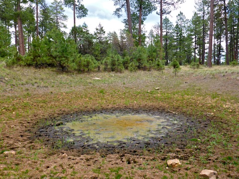
Instead, I continued along FR 123A to the world’s grossest cattle tank. I mean, seriously, it looked like a Superfund site. Just past the tank, is supposedly the intersection of FR 9707W. It may not look like there is a forest road there, but there is. Or was. There is no longer a tread, but if you pay close attention, you can see where the ground was levelled and brush cleared. 🧐
I followed ‘forest road’ 9709W for a third of a mile, before turning east down a mild drainage to just below Battleground Tank. The wash — which I assume is the “Big Dry Wash” in Major Evans’s AAR (after action review) — is easy travel, with no water, few rocks, and no grab & stabs. I worked my way along the contour line on the wash’s east slope until I emerged at FR 123E, just above the Battle of Big Dry Wash memorial.
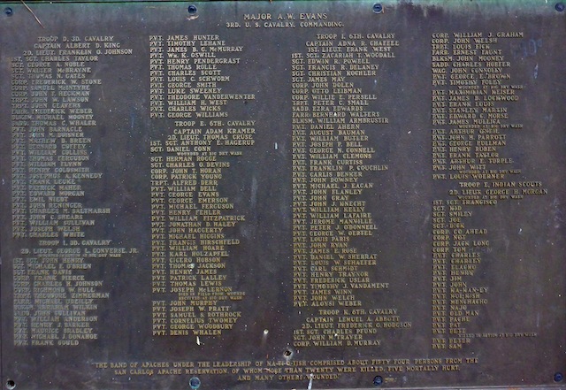
There were about a half dozen people at the memorial. On the front is a summary of the battle, and on the back is a list of all the United States Army’s participants by troop, rank & name. Some of the abbreviations are obvious, like “PVT”, but some less so: “TRPT” is trumpeter, “WAG” is wagoneer, “SADD” is saddler, “FARR” is farrier and “BLKSM” is blacksmith. “CPL Tom” (no last name) is famous Old West scout & bounty hunter Tom Horn. Other than Na-tio-tish, the Apache warriors are not named, or known.
I was intending to eat lunch at the battlefield memorial but the sky was getting very dark. There was thunder, and several nearby lightning strikes. Just like in 1882. I decided it best to bail with a quickness. ⛈
I made my way back over the old Apache positions, down into the wash, then cut back up another drainage towards FR 123A. I had to low crawl two barbwire fences, but luckily the bottom strand on both was unbarbed. (Which is actually recommended to avoid harming small critters.)
Back on trail, FR 123A came to a quick end before Arizona Trail Segment #27, began descending to East Clear Creek. Knowing the climb ahead of me, I took another break despite the dark clouds. Luckily, so far, all bark and no bite.
From East Clear Creek — which is bone dry at that point, upstream of Blue Ridge Reservoir — it is a 500 ft. climb in 0.7 miles to the top of the canyon. It may not seem like much — indeed, it’s the same as North Mountain in Phoenix — but I was already drained. It wasn’t so much muscular, as aerobic. I took standup breathers every hundred yards all the way up.
From the top of the canyon, AZT #27 continues east for .75 miles to a split. The Arizona Trail splits right; not sure where left goes. Maybe 200 yds. further east is another split. If you are thru-hiking the Arizona Trail, go left. After a final five minute sit down break, per the sign, I went right to Rock Crossing Campground, which was only another third of a mile. I was that exhausted.
On the way back to Phoenix, I-17 was the least crowded & stressful I’ve ever experienced it. Certainly nothing to the level of last week’s psychosis!
General Springs Cabin Directions: From Phoenix, head north on AZ-87, the Beeline Highway, through Payson, Pine and Strawberry. (Alternately, take I-17 north, then AZ-260 east.) 2.6 miles north of AZ-260, turn right onto Rim Rd. / FR 300. Rim Rd. is dirt and, at its western end, twisty and very bumpy. I would not do it in a car. In 12 miles, park at the Battle of Big Dry Wash historical marker, park a ¼ mile down FR 705 at General Springs Cabin.
Rock Crossing Campground Directions: Whether driving from Phoenix, or General Springs Cabin, from the intersection of AZ-87 and Rim Rd. / FR 300, continue north on AZ-87 for another 13.8 miles. Turn right on FR 751. In 2.4 miles, before reaching Blue Ridge Reservoir, turn right into the Rock Crossing Campground.
GPS File: Arizona_Trail_27_to_Rock_Crossing
Distance: 15.66 mi.
AEG: 1,074 ft.
Time: 5h 15m
Hiking Video
Arizona Trail: Passage 27, Mogollon Rim from Preston McMurry on Vimeo.