

I used to spend a lot more time hiking near Superior, back in 2014 and 2015. I’ve spread my wings since then, but I’ve always planned to return to Arnett Canyon & Telegraph Canyon.
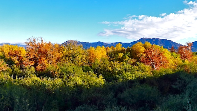
Despite its presence in the Sonoran Desert, at only 2,500 ft. elevation, Arnett Canyon is a hidden gem, especially in late Fall. Telegraph Canyon is not bad either. 🍂
I’ve hiked Arnett Canyon & Telegraph Canyon at least three times, including twice doing a complete Picketpost Mountain circumference hike. (Telegraph is on its south flank; Arnett on its east.)
My plan was to drive from US-60 down Perlite Rd. to Pinal City, using the ghost town as my trailhead. I drove east on US-60, all the way into Superior, without spotting the Perlite Rd. intersection. I then drove back west on US-60, realizing then that Perlite Rd. was just a culvert. I took the Boyce Thompson Arboretum exit, driving east past the Arboretum to a cul-de-sac. That’s when it dawned on me that not only had US-60 been widened a few years ago, but realigned as well. I was on old US-60, which used to connect to Perlite Rd. Argh! ✋
Armed with my in car GPS, and my handheld crappy Garmin 62S, I quickly figured out an alternate route to Pinal City. (See “Directions”, below.)
It was the dirt roads behind the Superior air strip were quite muddy, but nothing like when we tried to negotiate A-Cross Ranch Rd.
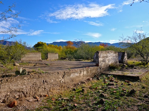
I started by hiking east along Queen Creek, looking for any signs of Pinal City. I knew there was not much left of Pinal — certainly nothing like Swansea! — but I managed to find one small bit of foundation. It was certainly not an extensive ghost town exploration.
After crossing Queen Creek, I began working my way back west, climbing up slope a bit, looking for a good angle to shoot some photos of Queen Creek’s still decent fall color. I’d had quite a bit of caffeine with my breakfast at Los Hermanos, in Superior, so I stoppped for a pee. I was mid-stream when a javelina wandered up within 50 ft. of me. That was quite concerning, especially being as “vulnerable” as I was. Thankfully, the javelina only sniffed in my direction. 🐗
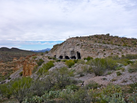
After avoiding the javelina, I checked out a whazzit, which turned out to be a fairly large, still intact, foundation, with several partial walls. It was in the general vicinity of the 76 Mill, but I don’t think that was it. It looked like a building foundation. Just in front was a well, and across a small wash, an adit that went in only 50 ft.
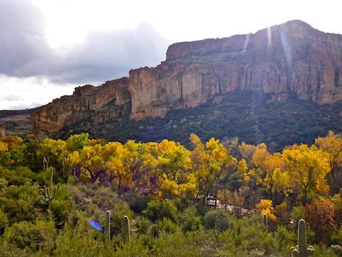
From the adit, I headed south up Perlite Rd. for a half mile to a saddle. Several large boulders, and a shot up gate, blocked vehicle access to the east. I turned west, up an unnumbered and rather rough jeep trail. Where the jeep trail petered out in a half mile, there was an excellent OP overlooking Arnett Canyon. The high angle Arnett photos in my hike video were taken from that OP.
From the OP, I followed the Arnett Canyon rim north northeast for a ¼ mile to the head of a small side canyon, which turned out to allow easy access to the main canyon floor. I followed a game trail most of the way down. Along the way, I passed the remains of a gate that was nothing but two rusty poles, no fencing. I also found a rock full of crystals, but it was too heavy to take with. 😕
Arnett Canyon was at peak fall color. Just spectacular the ¾ mile to Finger Rock. There was quite a bit of water in Arnett Creek, but no obvious flow.
Soon after starting southeast in Arnett, I came upon a gate. I remembered it being made of sticks & barbwire in 2015, but now it was made of square metal tubes of the same type I’ve seen on the Arizona Trail. That seemed odd: Cowboys don’t spend any more time and money building fences than they absolutely have to. Plus, I thought the AZT passed the west side of Picketpost Mountain, rather than the east, where I was. 🤔
Travel on trail along Arnett Creek was much easier than I remembered. Like brush had been cleared. In one spot, it was obvious that the side of the trails had been reinforced with placed rocks. At Finger Rock, and the junction with Telegraph Canyon, there was another square tube metal gate, piles of rebar, and sacks of (hardened) concrete. Someone’s been doing a lot of trail maintenance, but who, and how did they get all that gear in there? I know they didn’t hump it in.
Telegraph Canyon also had water and improved travel, though neither to the extent of Arnett Canyon. I did lose the trail once.
On a previous trip through Telegraph Canyon, I bumped into Mark “CannondaleKid” Formo, and his wife Tracey, who I know from HikeArizona.com. This time, in about the same location, it was another couple, doing the Picketpost Circumference with their dog. Small world. 🌎
There is an easy exit from Telegraph Canyon about a ½ mile southwest of Finger Rock. The canyon walls at that point are otherwise sheer, and several hundred feet high. The easy exit is only about 100 ft. and is on a trail with several orange ribbons. Looks like someone is doing trail work there as well. (Speaking of which, I’d seen little metal wire flags, trailside, along Arnett Creek.) At the top, it was easy crosscountry, past White Rock 3012, to FR4.
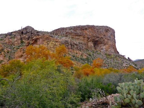
FR 4 is rugged, definitely a high clearance 4WD road. I hiked east on it. Just before the gravel pit / Superior outdoor gun range, I turned south up a small canyon, where I’d previously found the best fall color in the area. Not so this time. The densely cheddar colored grove was gone, with only a few leaves still clinging to the trees.
Back on FR4, I soon dropped back into Arnett Canyon, which is much shallower and easier to access than on the east slope of Picketpost Mountain. The ¾ of a mile north to Finger Rock had another square tube metal gate and had obviously had work done on the trail surface. That section of Arnett also had some very yellow leaves.
Just north of Finger Rock, I exitted Arnett Canyon via Perlite Rd., which is very rugged up to the strip mine on FR 2403. Maybe that’s how they brought in the new gates, and other trail supplies. A helicopter would have been easier. 🚁
Back at the shot up gate, Perlite Rd. improved, allowing me to book back to my trailhead in Pinal City. Good day, wonderful fall color. 🤗
Directions: From Phoenix, head east on US-60, past Gold Canyon and the Boyce Thompson Arboretum. With the recent realignment of US-60, to bypass the Arboretum, there is no longer a direct connection between US-60 and Perlite Rd. Turn right at Panther Dr., just before the Superior Circle K. In a ½ mile, turn right at the fire department, onto Telegraph Canyon Rd. In a ½ mile, turn right onto FR 989, which curls back north. In 1.3 miles, on the south side of the air strip, take a sharp left. I parked in 0.6 miles at the west end of the air strip, but you can continue on the road to the old Pinal City site in another ½ mile. 4WD not necessary, but I would avoid driving it in a car.
GPS File: Arnett_Creek_Telegraph_Canyon_2
Distance: 9.65 mi.
AEG: 1,190 ft.
Time: 4h 24m
Hiking Video
Fall Color in Arnett & Telegraph Canyon from Preston McMurry on Vimeo.
I’m going hiking with you next year, you know all the beautiful places to see!!!
You got it! 👍