

Last Easter, I completed the Maryland segments of the Appalchian Trail. That won’t seem like much to an AT thru-hiker who knocks out Maryland in two or three days, but it’s not bad for someone who lives 2000 miles away in Arizona. Particularly, when the temperatures on South Mountain are frequently lower than anything Phoenix experiences in even its worst nightmare.
I planned to hike from Pen Mar to Old Forge on Good Friday, but my son took the day off work, so my wife & I spent the day with him and his family instead.
My wife went antiquing on Saturday, while I packed plastic eggs and made my special chip dip.
On Sunday, we enjoyed watching our grandaughter Boo hunt for eggs. None of the guests ate my dip.
Monday dawned cold & rainy in Hagerstown. It was miserable enough that when I walked outside the hotel at 7:30 a.m. I turned right around and went back inside instead of driving off to Pen Mar. (Similar to our visit last October, when I hiked the C&O Canal Path from Maryland Heights to the Antietam Aqueduct.)
Two hours later, the temps were a little more tolerable, and the rain had stopped, so off we went. As we headed east, towards South Mountain, it was obvious that the slight elevation difference was enough to put snow along the ridgeline.
At Pen Mar Park, there was an inch of snow on the ground. But it wasn’t windy, and the temp was probably just above freezing. Certainly not as cold as when I hiked the Appalachian Trail from Crampton Gap to Turner’s Gap five years ago.
I started hiking at 10:30.
The Appalachian Trail is on the west side of Pen Mar Park. It drops down to some railroad tracks, on the opposite side of which is the Mason-Dixon Line, which is Maryland’s border with Pennsylvania. The Mason-Dixon line is signed and has a trail log.
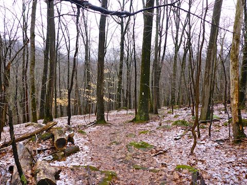
The A.T. then crosses PA-550, before descending to Falls Creek (0.8 mi.), which is spanned by a wooden bridge. As I descended, the snow on the ground gradually disappeared until there was none at all at Falls Creek. Like all the creeks on this hike, Falls Creek had plenty of water.
After crossing Falls Creek, the Appalachian Trail ascends 650 ft. in a mile to just below the summit of Mount Dunlop. It’s the only climb on this A.T. segment. Halfway up, the A.T. crosses Buena Vista Rd., which has blind curves on either side, so keep an eye out for traffic (despite Buena Vista being a minor road). Also keep an eye out for where the AT continues on the north side of the road: It’s easy to miss.
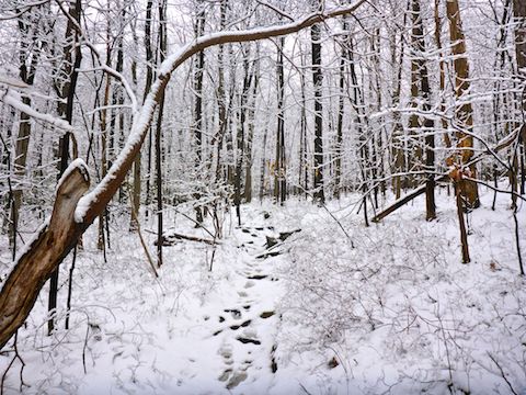
The further up Mount Dunlop I hiked from Falls Creek, the more snow there was. At it’s deepest — about 3″ — the Appalachian Trail would have disappeared if two or three hikers had not passed by earlier. Just enough traffic to indicate the path, but not enough to muddy the trail surface. It was beautiful & peaceful, and not at all cold.
“Summiting” Mount Dunlop, and continuing on to the Blue Ridge Lookout will add about 0.75 miles and 200 AEG to your hike. I couldn’t pass up the summit, no matter how minor. I was surprised how easy the cross country travel was, despite the deeper snow. The threat of buried ankle breakers appeared hollow. I used an icy branch as a tripod for the summit segment of my hike video (below). I totally spaced Blue Ridge Lookout.
The rest of the elevation gain on this A.T. segment are rolling up & downs of 100-200 ft., at least heading north.
From Mount Dunlop to entering the Michaux State Forest (3.40 mi.), the Appalachian Trail crosses four roads and one creek, Red Run. Three of the roads are paved, including heaviy trafficked PA-16. The dirt road, Rattlesnake Run Rd., is the back road into Old Forge. (When I met my wife at Old Forge, our rental SUV was covered in dirt, as she decided to have some fun.) Just north of Rattlesnake Run Rd., there is an unnamed spring.
By the time I got to PA-16, the ground was again clear of snow, other than random spots of thin, icy crust on moss or dead leaves.
Deer Lick Shelter (4.8 mi.), is two small three-sided, single-story, shelters. There is a small metal stove, two camp fire rings, two levelled tent stands, a spring and a privy, but no bear box.

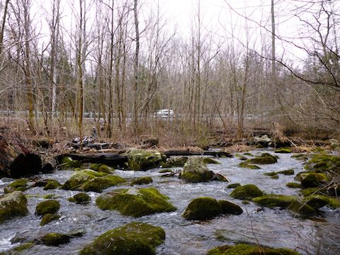
A half mile past the shelter, the Appalachian Trail descends 650 ft. in about two miles to Old Forge. The trailhead is in the town park, just north across several more creeks, including the East Branch of Antietam Creek, which gave its name to the bloodiest day in American history. There is a A.T. shelter on the south bank, opposite the park, but I did not check it out.
If you don’t have a loving wife waiting for you like I did, doing an out & back, would double the distance — duh! — and be about 2,800 AEG.
Unlike the Maryland A.T. segments, between Pen Mar and Old Forge the trail is very rarely rocky, and even then only mildly so. Even in very wet & snowy conditions, the surface holds up well, never getting too muddy, even when it had inch deep puddles like I found on the descent to Old Forge.
GPS File: AT_Pen_Mar_to_Old_Forge
Distance: 8.39 miles
AEG: 1,362 ft.
Time: 2h 59m
Appalachian Trail Video
Hiking Pen Mar to Old Forge, Appalachian Trail from Preston McMurry on Vimeo.
Snow! I love it. I liked your showing yourself hiking. Nice touch.